


Written in collaboration with Duke CTI Practicum (Fall 2020 Cohort)
Executive Summary
Urban Air Mobility (UAM) is expected to transform transportation in the coming decades. While the industry is still in its infancy, one of the most compelling short-term use cases is last-mile drone delivery of essential medicines and vaccines to rural destinations where the cost structure of ground shipping is prohibitively expensive.
Building on our work with NASA to develop a comprehensive, industry-standard 3D urban airspace map, this post describes how government and industry partners can leverage UrbanFootprint’s urban intelligence platform for each key step of the UAM planning process: community prioritization; low-altitude route planning; site selection and operational planning. Given its ability to generate precise, actionable insights at each of these steps, UrbanFootprint can help to make robust, data-driven decisions for last-mile drone delivery planning — all from a single platform.
The Case for Rural Areas
Rural communities in the U.S. do not benefit from the same access to commercial delivery services as urban and suburban areas. In remote locations, companies such as FedEx and UPS cannot turn a profit due to high labor costs associated with long delivery distances, so they simply do not deliver. As a result, the U.S. Postal Service (USPS), an organization already plagued by labor shortages in rural areas (an issue exacerbated by COVID-19), is burdened with a higher volume of parcels, which strains the organization, reducing delivery timeliness and reliability.
The problem of reduced delivery service becomes more pronounced when accounting for the higher incidence of chronic health issues that rural populations suffer compared to urban populations, and that 20% of adults over 40 with a chronic condition receive their medicine by mail. Higher delivery costs further compound the problem because the rates of poverty in rural areas are higher than in urban ones.
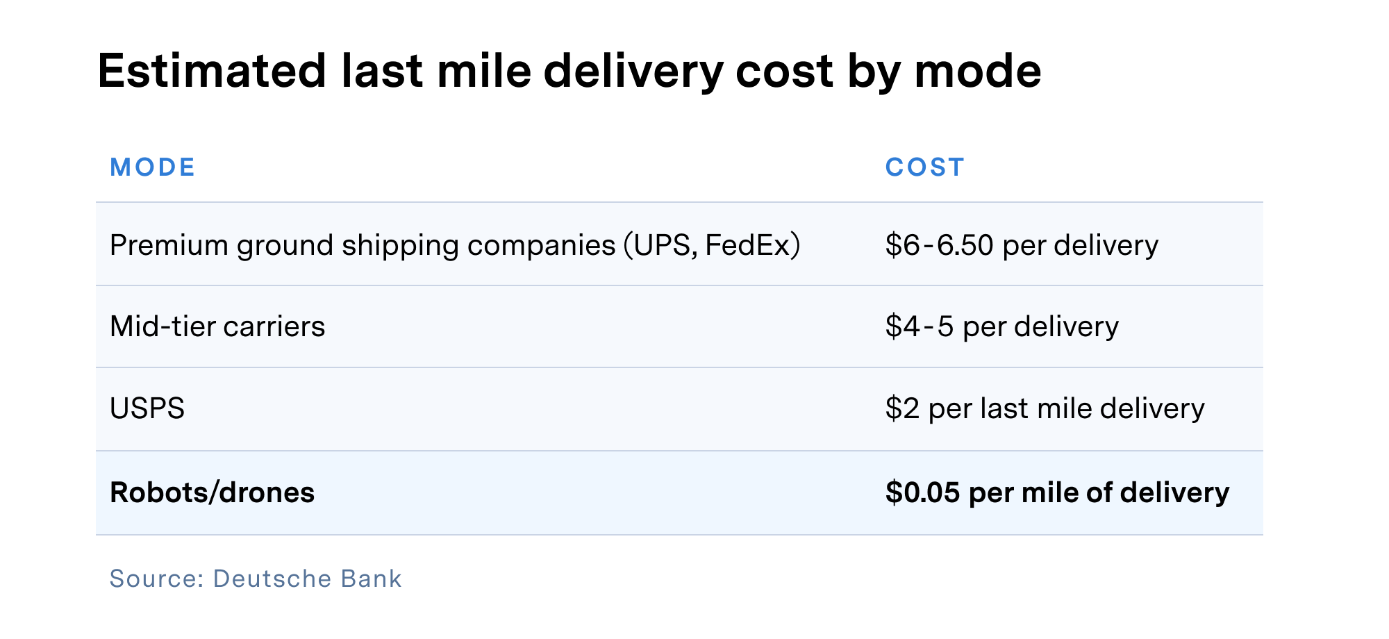
On the subject of delivery cost, it’s worth noting that an analysis by Deutsche Bank found that last-mile delivery by drone is substantially less expensive than conventional shippers. Such potential cost savings would translate into wider profit margins for delivery providers and reduced shipping costs for consumers.
All in all, their reduced access to (and therefore higher cost burden by) delivery services, combined with high levels of poverty and chronic medical conditions — themselves risk factors for increased severity and poorer treatment of COVID-19 infection — make rural areas ideal for the use of drones in last-mile delivery of essential medicines and vaccines.
Community Prioritization
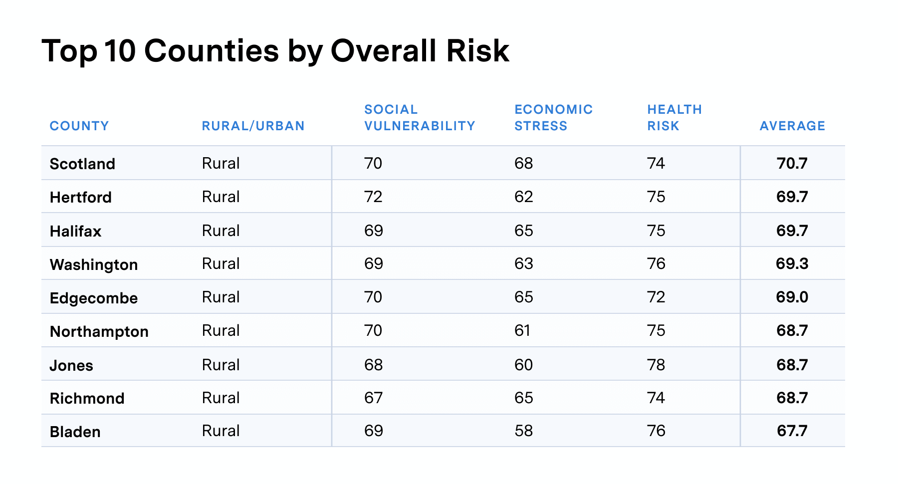
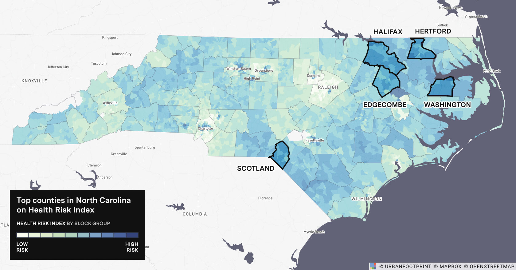
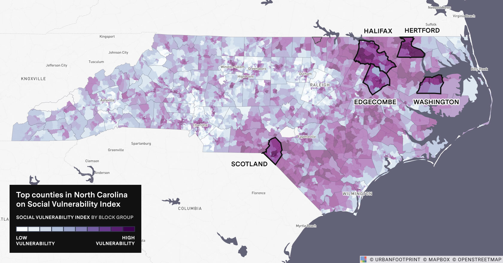
Presuming their use in rural areas, the first step to planning drone delivery of essential medicines and vaccines is to decide which communities should be prioritized. This is where UrbanFootprint can help, by identifying rural, at-risk populations who would most benefit from increased accessibility to medicines and vaccines through more timely and cost-effective delivery. Focusing on North Carolina, whose state government has been on the forefront of drone last-mile delivery through their involvement with the FAA’s Integration Pilot Program (IPP), we’ll use UrbanFootprint’s Health Risk, Economic Stress, and Social Vulnerability indices to identify locations with poor community health and high poverty rates. The indices are derived from a regularly updated analysis of various static and dynamic datasets detailing socio-demographic, economic, and community health information. Ultimately, UrbanFootprint provides a single score (0–100) per index. Scores are provided at varying levels of granularity (city, county, census block group) to suit your unique planning needs.
Within UrbanFootprint, adding a map layer of zip codes for which UPS applies extended delivery area surcharges enables us to prioritize communities affected by increased shipping costs. By layering index scores and increased shipping cost regions, we can quickly identify rural locations ideal for deployment of last-mile medicine and vaccine delivery services. With some locations in mind, we can zoom in further in the platform to narrow down these general locations to a specific community.
In rural areas with already few options for delivery, the scarcity of local pharmacies further restricts access to essential medicines and vaccines. So, it makes sense to select for locations with few local pharmacies or other medical facilities such as hospitals. Additionally, pharmacies serve as the de facto repository for medications, and are likely to be critical in the distribution of a potential COVID-19 vaccine due to their cold-chain storage capabilities. Thus, the locations of local pharmacies will inform operational decisions downstream.
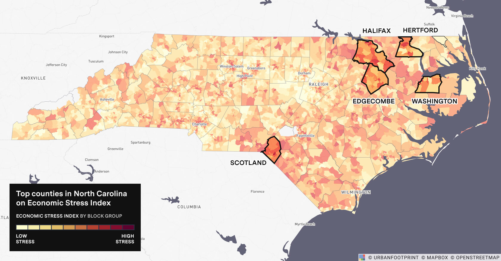
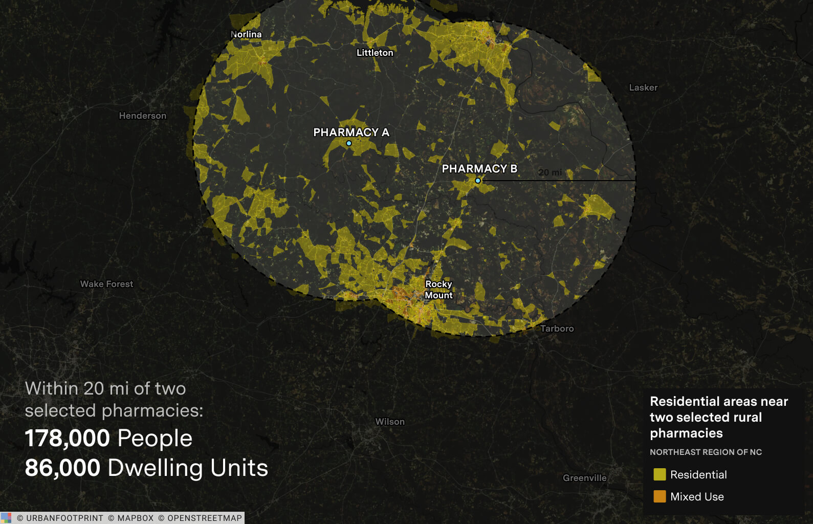
To do this, we’ll create a project in UrbanFootprint encompassing Halifax and Edgecombe Counties in northeast North Carolina which were selected based on their high relative risk values, as identified by the UrbanFootprint indices and the fact that they are in UPS delivery surcharge areas. Next, we’ll add pharmacy and hospital location layers, along with additional map layers in the platform that provide geospatial information on rates of poverty and chronic diseases.
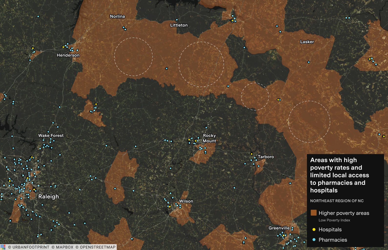
On the map of the same region, we can overlay zones of delivery area surcharge zip-codes to determine where it might be more cost-effective to provide last-mile drone delivery.
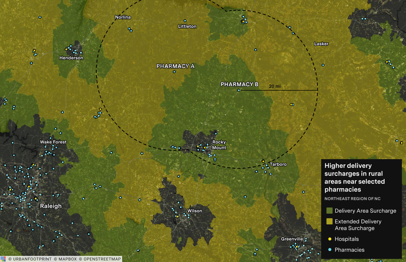
Combining the areas of 20-mile radius around each of two selected pharmacies (A and B) results in a larger area that meets all three criteria:
- Ranked highly in each of the three indices
- Subjected to delivery area surcharges due to rural location
- Limited in the number of local pharmacies and hospitals
Thus, the population in that area is likely to benefit significantly from the reduced cost, and timely, reliable delivery of essential medicines and vaccines. What’s more, because of the lower labor costs and improved efficiency, delivery service providers can make these deliveries without forfeiting profits.
This analysis also enables the selection of two pharmacies to serve as “warehouses” or “distribution centers” for the medicines and vaccines (those in the center of the designated circle above). Leveraging these two pharmacies as distribution centers would allow an operator to service a rural population of 178,000 (covering 86,000 dwellings, 67,000 of which are detached, single-family, large-lot locations) with much needed timely and cost-efficient delivery.
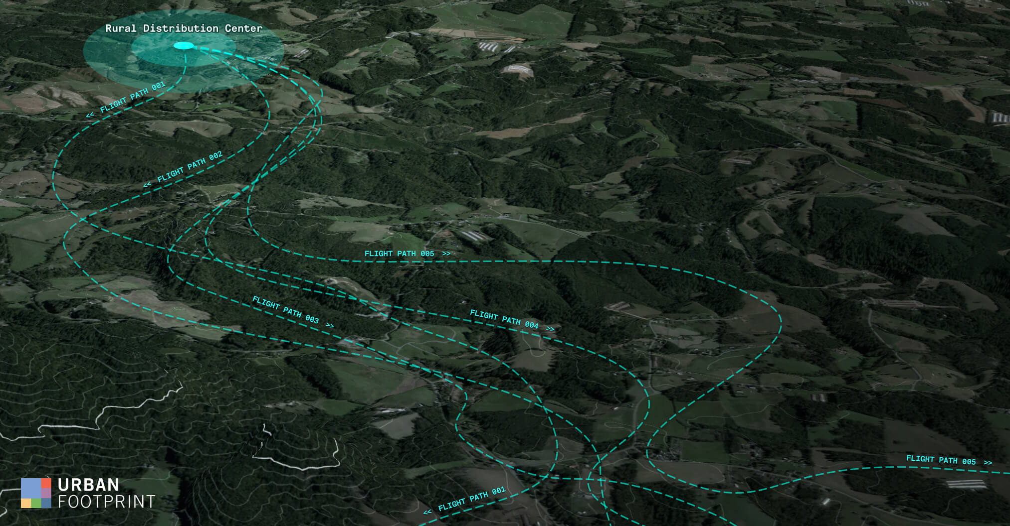
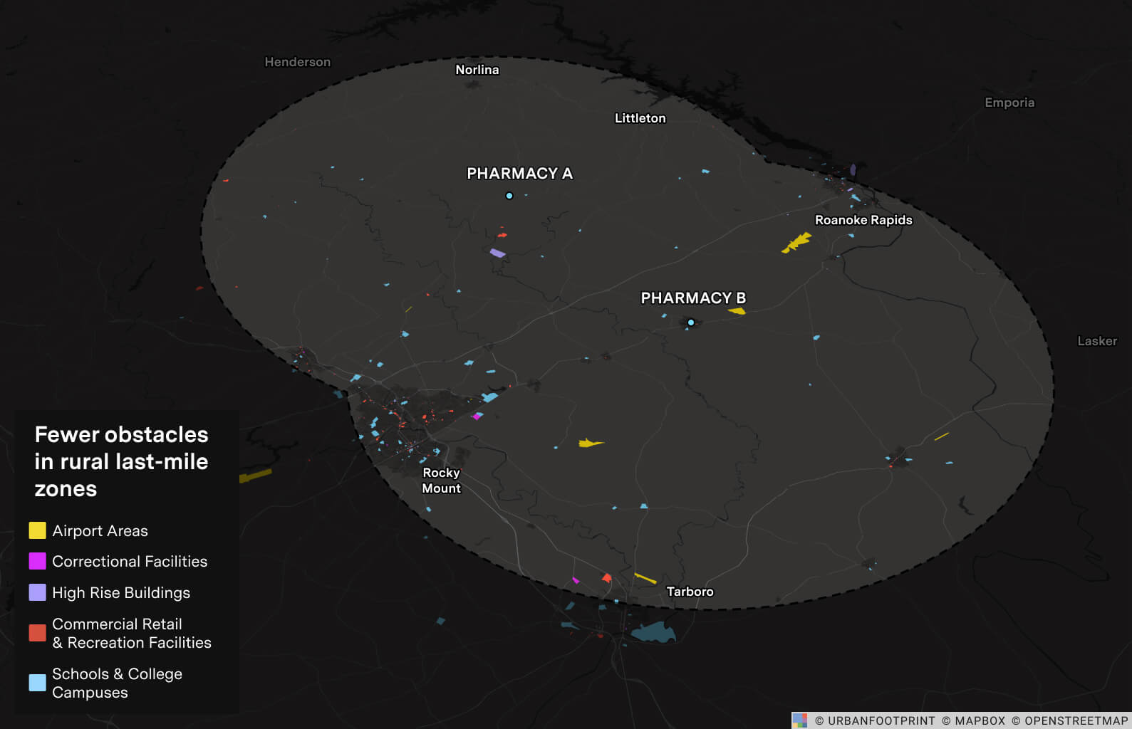
Low Altitude Airspace Route Planning
Another step where UrbanFootprint can help in the planning of UAM delivery is to streamline route planning analysis. According to the FAA, routes should be chosen to reduce risk and maximize safety. UrbanFootprint integrates hundreds of geospatial data layers from government and other public sources, enabling users to collect relevant information quickly and easily. Population density, road location, infrastructure type, building heights, and any hazards present in potential flight routes can easily be displayed and analyzed. Also integrated into the platform is FAA data on low-altitude operational ceilings, indicating how high a drone can fly in a given location to ensure there’s no conflict with existing heliports or airport landing/takeoff procedures. The image below depicts a few of these capabilities: highly populated areas are indicated, and other information relevant to route planning (airports, high rise buildings, schools, water, correctional facilities and more) is displayed.
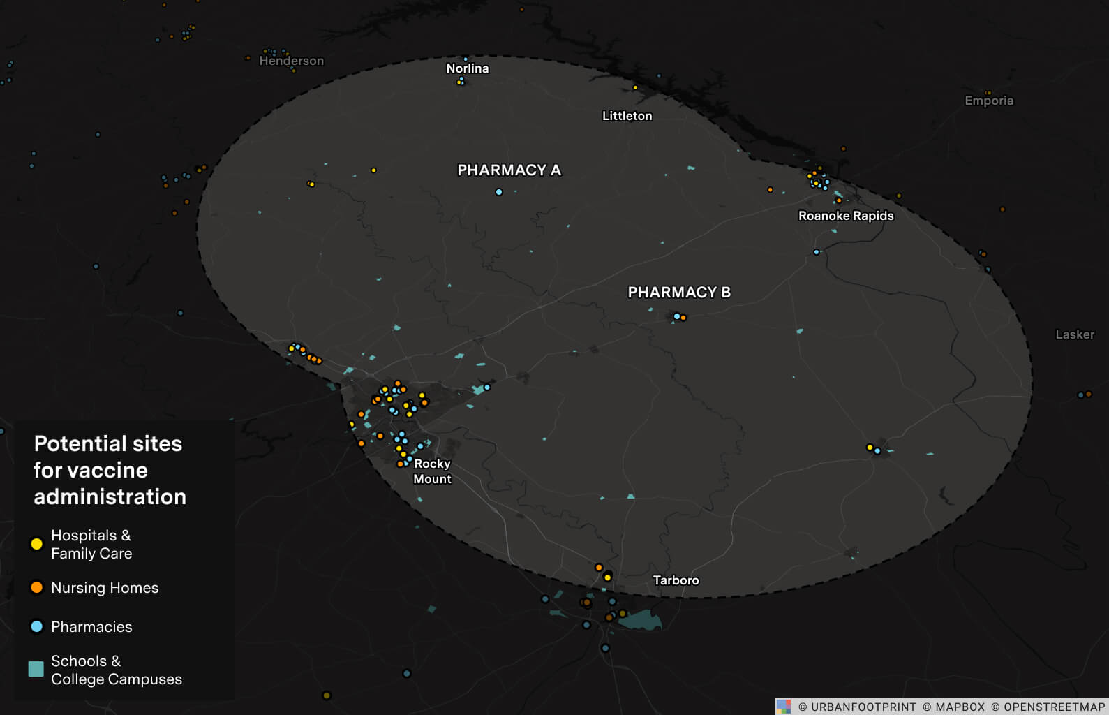
Site Selection & Operational Planning
After prioritizing specific communities and streamlining route planning, the final step where UrbanFootprint can help in planning drone-based last-mile delivery is in site selection and operational planning. Due to the sparse populations of rural areas, delivery points are positioned much farther apart than their urban counterparts. While this incentivizes drone delivery in rural areas (because of the labor costs of driving long distances between deliveries), it also poses some technical challenges. First off, the delivery range of drones is largely a function of battery life — which, while improving every year, is still limiting. Today, the typical range for delivery drones carrying small parcels is roughly 40 miles. Additionally, rural areas have limited infrastructure, including a lack of warehouses, distribution centers, and retail locations for drone landing. For the purpose of delivering medical supplies, it’s important to note that there are very few pharmacies in remote areas, so the ones that do exist will likely need to be leveraged as distribution centers. At the same time, some aspects of drone operations are easier in rural areas, most notably due to the lack of flight-route obstacles typical in densely populated areas.
In the case of providing medical supplies to the selected region, pharmacies would be an ideal source of supply since they provide both prescription and over-the-counter medications. A single location could serve as both a warehouse and distribution center, able to store, package, and ship products as well as store, load, and charge delivery drones. Assuming this, with a 20-mile flight range (40 mile round trip for a single delivery), possible concepts of operation for rural UAS last-mile delivery of essential medicines and vaccines might include:
- Direct Route from Pharmacy. Packing and recharging stations would be located at or next to the pharmacy to facilitate the loading, launch, and return of the delivery drones. This method would cover an estimated 20-mile radius around a selected pharmacy.
- Fixed Warehouse/Distribution Center. A building that acts as a warehouse and distribution center would be placed 20 miles from the pharmacy. Drones or trucks would then transport products from the pharmacy to the warehouse, wherein drone exchange or recharging would take place before final delivery of the package. This method would cover up to 40 miles from the selected pharmacy.
- Mobile Distribution. Trucks storing drones and equipped for drone launch would transport products from the pharmacy to various parking locations, load the products onto the drone, and then launch for delivery up to 20 miles from the parking location. Drones would return to the trucks to recharge and reload.
While delivery of essential medicines directly to residences poses a few logistical challenges, distribution of vaccines, including a potential COVID-19 vaccine, requires additional considerations. One of these is maintaining required storage temperatures. The government has already partnered with major pharmacies to leverage their cold-chain storage facilities for distribution of a COVID-19 vaccine, so once again pharmacies are likely the best distribution centers. Another consideration is selecting sites for administration of the vaccine, including local health clinics, long-term healthcare facilities, schools and other establishments. In rural areas, where few medical facilities are present, this can prove difficult. Distribution planners can use UrbanFootprint to view locations of numerous facility types to help select these administration sites (as well as the best drone-delivery concept-of-operations to get the vaccines there).
Location Intelligence for Smarter Drone-Delivery Planning
Whether you’re looking to prioritize a community, determine suitable flight routes, select the most suitable concept of operations, or identify appropriate infrastructure locations, UrbanFootprint can help to make smarter, data-driven decisions for last-mile drone delivery planning — all from a single platform. Planning a last-mile delivery operation? Get in touch and see how we can help.
