


If you’re interested in creating a project like this, let us know!
We are thrilled to announce our partnership with The Nature Conservancy. Our shared mission to support “great green cities” inspired the creation of The Nature Conservancy’s Conservation Module, an analytics tool built into UrbanFootprint to help planners and communities quantify the environmental impacts and benefits of land use policy and development choices. As we prepare for a doubling of global city population by 2050, it’s imperative for sustainable land use and natural conservation to be a focal point in urban and regional planning. Creating communities where both people and nature thrive is essential to pursuing a sustainable, resilient and equitable future.
In this post, we’ll share how the Conservation Module works and how Sonoma County is already using UrbanFootprint and the Conservation Module to alleviate the region’s acute housing shortage with minimal impact on natural and agricultural lands.
How Does the Conservation Module Work?
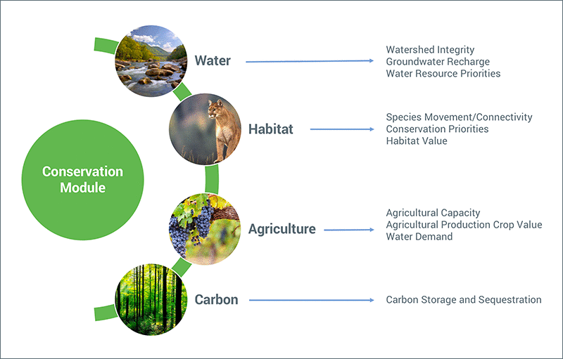
The Conservation Module is built to help planners, analysts, and advocates quickly understand the impacts of proposed plans and policies across four key themes: water resources, habitat impacts, agriculture, and carbon sequestration and storage.
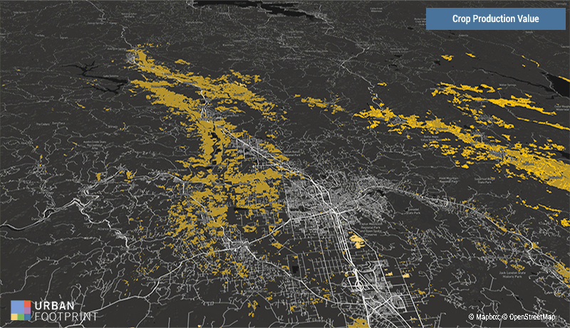
By standardizing land cover types, reference data, and calculated model inputs across California, UrbanFootprint allows planners to analyze existing conditions in minutes and efficiently distill actionable insights from future land use scenarios. This includes the potential impacts and benefits to natural and working lands and the values these lands deliver to communities.
The Conservation Module builds on UrbanFootprint’s suite of analytics – Emissions, Transportation, Resilience, Accessibility, and more – so planners can easily evaluate conservation in the context of a range of key community impacts. Now, rather than struggle to align often disparate datasets, UrbanFootprint users can visualize impacts on natural and working lands along with metrics like vehicle-miles traveled, transit accessibility, household costs, and beyond.
To illustrate this process, let’s walk through a case study from Sonoma County and their efforts to address the region’s housing crisis while minimizing the impacts to natural and working lands.
Planning for Housing Growth and Minimal Environmental Impact in Sonoma County
In partnership with The Nature Conservancy, the Sonoma County Agricultural Preservation and Open Space District, and the Regional Climate Protection Authority (RCPA) the Conservation Module was used to support an UrbanFootprint-powered planning process in Sonoma County. As Sonoma County sought a path to support housing growth with minimal impact on the environment, a range of scenarios was created to evaluate the costs and benefits of each option. This challenge has only been heightened in the wake of the catastrophic 2017 wildfires which destroyed more than 5,000 homes in the County, placing more pressure on an already strained housing market and sensitive environmental resources.
The three scenarios ranged from lower density suburban growth patterns to higher density housing options with an emphasis on infill development.
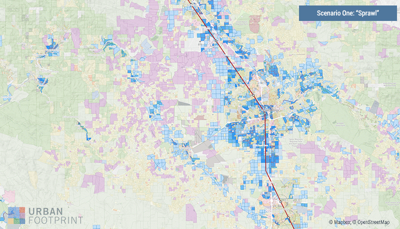
Scenario One depicts a lower density suburban growth pattern where urban growth boundaries (UGB) are not enforced. Scenario Two projects current development patterns and growth trends. Scenario Three displays a higher density housing option with an emphasis on infill development opportunities near new SMART commuter rail stations.
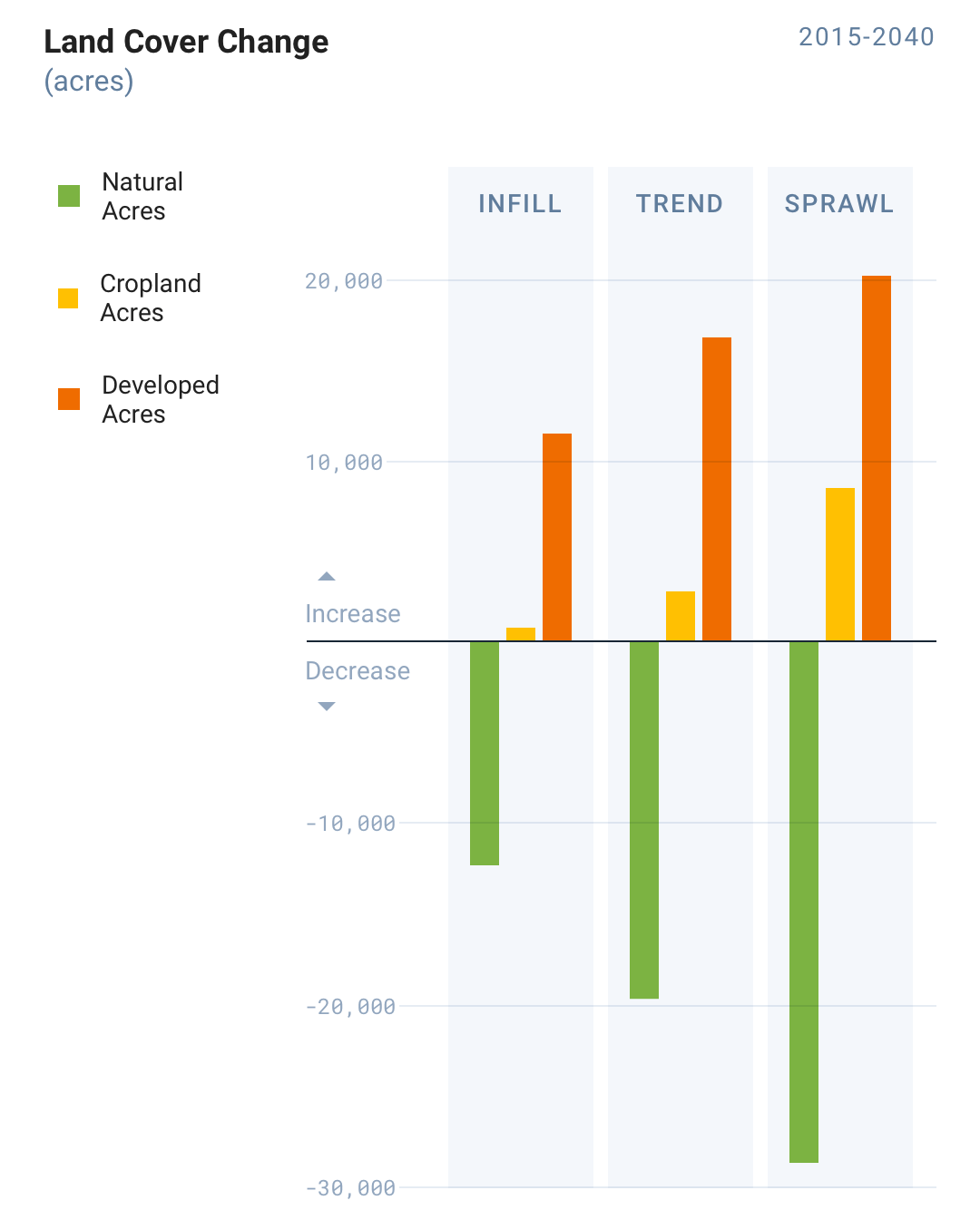
After running the Conservation Module in UrbanFootprint, we were able to evaluate the environmental results across the three development scenarios for Sonoma County.
Below, the Conservation Module calculates the “Infill”, or compact growth scenario, would save over 16,000 acres of natural land when compared to the “Sprawl” or lower density growth pattern. That’s a 57% reduction in natural land lost to development.
But the Conservation Module doesn’t stop at assessing the amount of natural land lost to development. It reports on the values that those lands contain, such as carbon sequestration and storage, water and habitat.
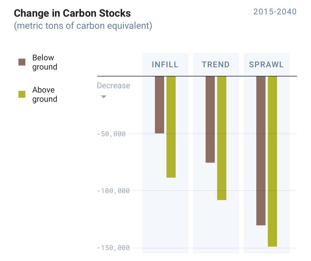
For example, we assessed the scenarios’ impact on above and below ground carbon stocks. Vegetation is a critical tool in fighting climate change as trees and shrubs absorb carbon dioxide out of the atmosphere and store the carbon in their branches, trunks, roots, and in the soil. The “Infill” scenario saves over 60,000 metric tons of above-ground live carbon stocks when compared to the “Sprawl” scenario. This results in climate change mitigation benefits equivalent to taking 46,000 passenger vehicles off the road per year. When also considering soil carbon stocks, the avoided development on natural lands from the “Infill” scenario saves over 80,000 metric tons of carbon equivalent compared to the “Sprawl” scenario. This avoided conversion produces climate change mitigation benefits equal to removing nearly 63,000 passenger vehicles from the road per year.
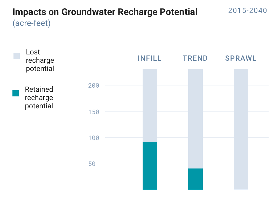
 The Conservation Module also analyzed groundwater recharge potential for each scenario. Increasing the impervious surface through development can reduce the recharge potential of a landscape. “Infill” saves 92 acre-feet of potential groundwater recharge and 41 acre-feet in “Trend” when compared to the “Sprawl” scenario, respectively.
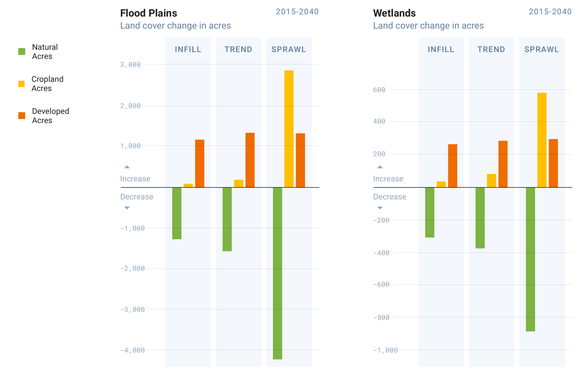
Here, we also used the module to understand the effect on priority water resource areas in the region. Natural lands within floodplains help to absorb flood waters and reduce flood risk to downstream residents. Nearly 3,000 natural acres of floodplains would be saved in “Infill” compared to “Sprawl”. Wetlands help maintain and enhance water quality, sequester carbon, and provide important habitat. 600 acres of wetlands would be saved through more compact development (‘Infill’) compared to ‘Sprawl’.
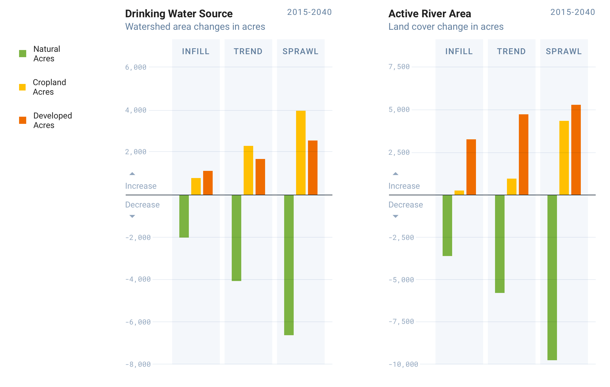
Natural lands in watersheds and riparian areas can filter sediment and pollutants from runoff, protecting and enhancing water quality for downstream residents, farmers, and ranchers. The “Infill” scenario would avoid development in almost 5,000 natural acres of watersheds used as a drinking water source when compared to the “Sprawl” scenario helping to keep drinking water clean. In addition, “Infill” would avoid development in over 6,000 natural acres in riparian areas compared to the “Sprawl” scenario helping to maintain and improve water quality in Sonoma’s rivers.
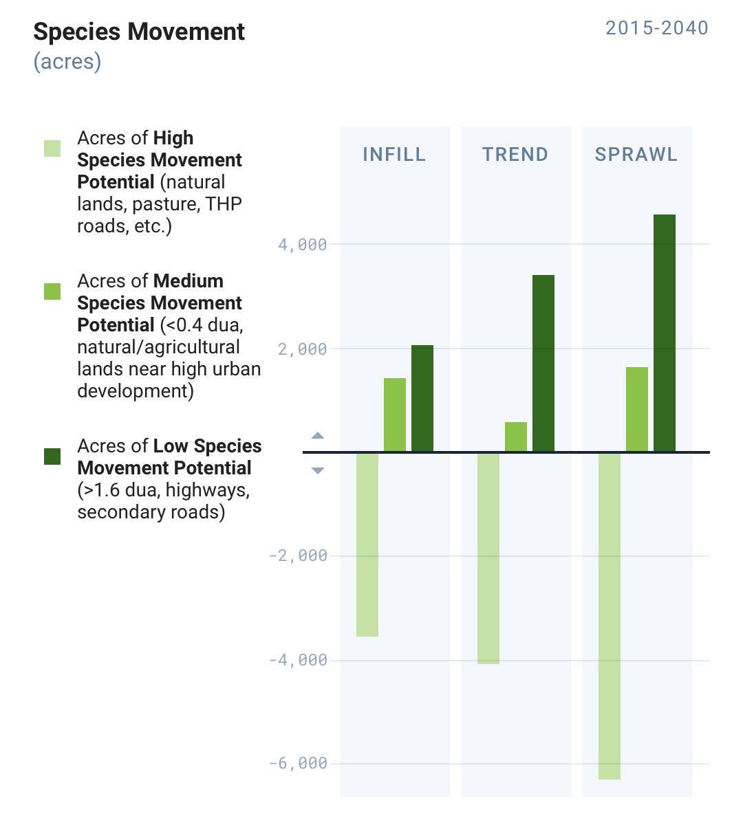
Finally, the chart below illustrates the Conservation Module analysis of the three scenarios’ impact on species movement. “Infill” would protect nearly 3,000 acres of area with high species movement potential compared to the “Sprawl” impacts helping Sonoma County’s wildlife traverse the landscape.
With the ability to quickly understand and visualize the impacts of our land use choices, planners have the tools they need to clearly communicate the costs and benefits of each scenario and inspire data-driven conversations to effect positive change.
Conserving Natural Lands and Supporting Healthy Communities
The Conservation Module serves to clearly demonstrate the impact and benefit of proposed plans and policies on the natural and agricultural lands and the values that those lands contain for communities. While the Conservation Module is only available in California for now, we hope to scale this feature across the nation. Clear communication of science-driven conservation and planning impacts to lawmakers and community stakeholders is critical in supporting sustainable communities and protecting our natural resources and working lands.
Ready to see the Conservation Module in action? Request a custom demo with our team to get started. In the meantime, we invite you to tweet or email us your thoughts and questions.
