


Map-making just got easier. Explore the game-changing new features in our Winter 2019 release that deliver best-in-class cartography with UrbanFootprint. We’ve been working hard to incorporate customer feedback and are excited to unveil the most powerful web-based planning and analysis tool for generating robust and visually compelling maps and analysis.
Read on to learn about all the new features in the Winter 2019 release!
Easy Layer Management
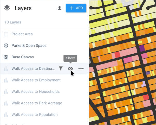
One of UrbanFootprint’s most valuable features is the ability to add layers to your maps by using UrbanFootprint’s extensive library of built-in reference datasets and analysis module outputs.
UrbanFootprint’s enhanced layer manager makes it easy to interact with layers to quickly create maps. You can show and hide layers with a click, drag and drop layers to reorder them, and easily see which layers have filters or selection applied. The updated layer manager provides an intuitive, easy-to-use experience for managing your map’s layers to meet any planning job at hand.
New Base Map Options
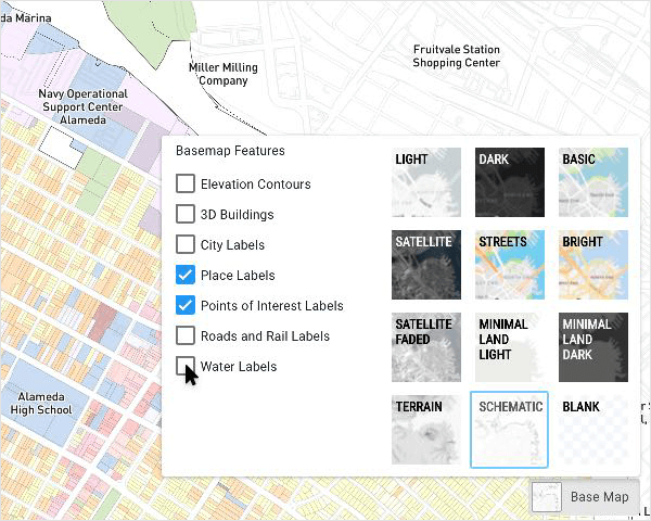
This release includes new features to upgrade your map design. You can now select from twelve different base map options, including streets, satellite, terrain, schematic, and more. You can also select which labels to display on your maps, including city names, places, points of interest, roads and rail lines, and water bodies.
Symbology Enhancements
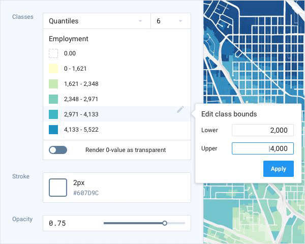
Flexible layer symbology is at the heart of great cartography. This release includes powerful new symbology features that allow you to customize the appearance of your maps with ease. Once you’ve added layers to your map using the built-in reference layers (or your own custom layers), it’s simple to visually customize your map.
In addition to making map symbology much easier to use, we’ve added major new symbology features. You can now:
- Style a layer according to whether it contains points, lines, or polygons.
- Use UrbanFootprint’s auto-generated classification methods, which includes options for equal interval, quantiles, and algorithmic.
- Easily create your own custom data classes or bins and style them.
Saved Map Positions
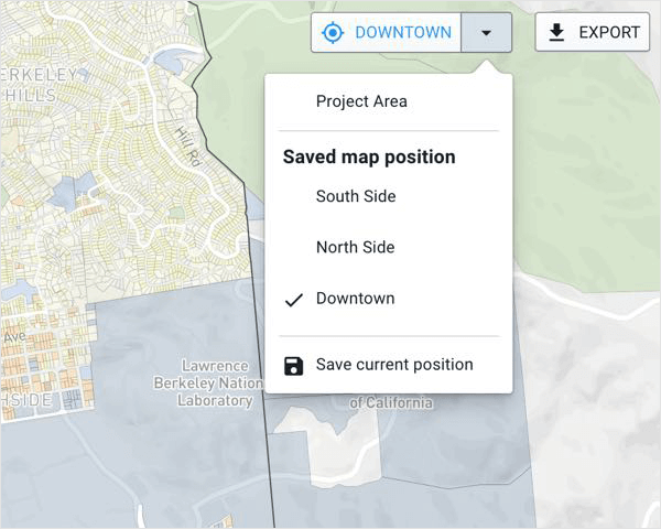
Saving consistent map views has been a popular feature request. Once you’ve created a map you like, you can now bookmark its position and return to it in the UrbanFootprint application whenever you like.
You can add and remove as many bookmarked positions as you need. This makes it easy to create maps with different orientations, return to them anytime, and export your maps without having to reposition them manually. This feature is a major timesaver!
Improved Map Export Capabilities
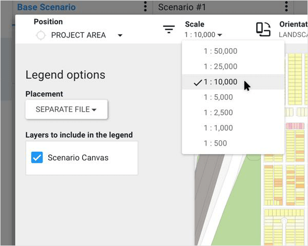
UrbanFootprint’s layers, reference data, analysis modules, and symbology editor enable you to create impressive maps in record time. Of course, you ultimately need to generate those maps in the right presentation format for your audience.
This release includes major enhancements to UrbanFootprint’s map export feature. Now you can export maps with your desired scale, orientation, size, and quality. Additionally, you can export your maps as a PNG file or download individual layers in shapefile, CSV file, or vector (SVG) format.
New Data Layers
![]()
In addition to all the powerful mapping enhancements in UrbanFootprint, we’ve added some great new datasets. You can now access nationwide building footprints, sea level rise data (COSMOS and CalAdapt), and fire risk data and easily overlay this data on your maps. We’ve also added the latest 2018 nationwide transit system data (GTFS lines and stops) and made major performance improvements to the Transportation and Accessibility Modules.
We are making updates and adding new layers to our data catalog every week. Let us know if there’s something you’d like to see!
See UrbanFootprint in Action
We hope you’re excited by all the powerful new mapping features in the Winter 2019 release. Ready to learn more? Book a demo to see UrbanFootprint in action.
As always, if you have ideas for new features or improvements we can make to UrbanFootprint, please send us an email with your thoughts!
