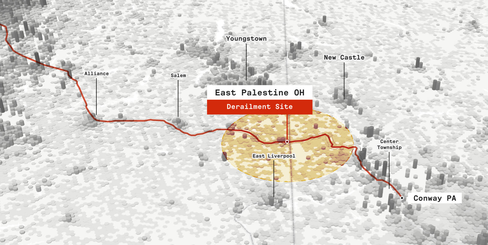
On February 3, 2023, a Norfolk Southern freight train carrying toxic chemicals derailed in East Palestine, Ohio, causing significant damage to the environment and the local community. The impacts of the crash are likely to be far-reaching and felt for years to come.
Despite initially receiving widespread media coverage, attention on the incident is beginning to wane. But this train derailment is not an isolated event. Additional train derailments have continued to occur in the United States since the one in East Palestine. In Anacortes, Washington, more than 3,000 gallons of diesel fuel were spilled. In North Dakota, 31 cars of a train carrying hazardous materials derailed, spilling petroleum used to make asphalt. And in Minnesota, a train carrying ethanol derailed and caught fire, prompting an evacuation for residents.
It is clear, something must be done to improve our critical infrastructure like railways to reduce the likelihood of additional crises. While these subsequent derailments have resurfaced the issue, unfortunately freight train derailments are quite common, and they disproportionately occur in mostly rural areas – so they may be easy for people to dismiss.
It is important to recognize the severity of the accident in East Palestine and its potential long-term impacts, letting it serve as a warning. In this blog, we aim to tell the story of the event through the use of maps. Through cartography, we explore the context and shed light on two crucial points: First, the long-term impacts of the crash are likely being underestimated. Second, it is crucial to invest in rail infrastructure to address safety concerns, improve community resilience, and minimize the risk of similar or worse accidents from happening in the future.
What happened?
The freight train had 53 cars derail less than one mile from the Ohio/Pennsylvania border. Five of the train cars contained the hazardous material vinyl chloride. Additional cars contained other chemicals for concern. The National Transportation Safety Board published a report concluding that an overheated bearing in one of the axles sparked a fire that caused the derailment.
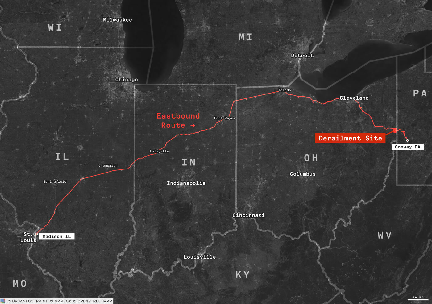
The immediate impact of the accident has been felt by the local community, with many residents
forced to evacuate their homes due to the risk of toxic exposure.
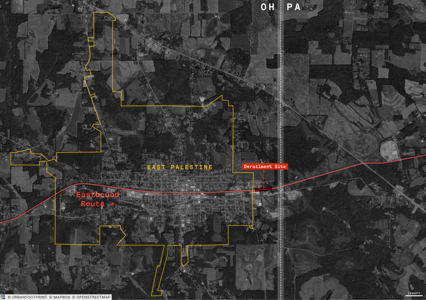
A look at our data tells us that there are 52,000 People that live within 10 miles of the crash site.
Within just 25 miles of the site, the number of potentially affected people increases more than 10x, to 585,000 across 12 counties – 6 in Pennsylvania, 5 in Ohio, and 1 in West Virginia.
While the derailment occurred in a rural area, there are many more densely populated municipalities close by. As you can see in the map below, when we look at the population density of the surrounding area, the crash was not far from much larger cities such as Cleveland, Arkon, and Pittsburgh.
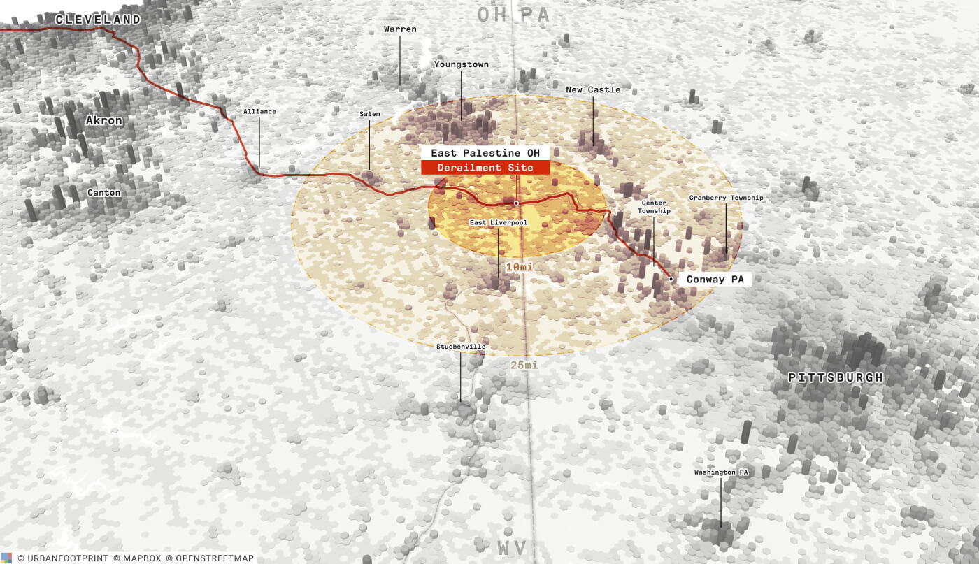
While the scale and severity of the impact to these larger cities is still unclear, the environment and local economy immediately surrounding East Palestine has been significantly affected. Many residents have been complaining about feeling sick in the weeks following the incident, and there could be many more long-term impacts on local ecosystems. Let’s take a look at some maps to help contextualize the impact on air and water quality, local agriculture, and more.
Air Quality
One of the most significant impacts is on air quality. The chemicals that were spilled during the crash can have a serious impact on the health of those exposed to them. In the immediate aftermath, emergency responders warned local residents to stay indoors and avoid exposure to the toxic fumes. On February 6, three days after the accident, the railroad company began a “controlled release” of chemicals that were in five of the cars, warning people in the red and yellow areas in the map below to evacuate to avoid serious injury, illness or death.
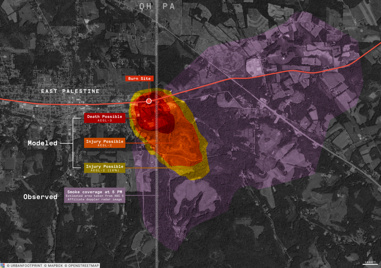
It is important to note that the modeled, or anticipated area that would experience dangerous levels of pollution is much different from the observed, or actual area (purple) in which smoke was measured by the local ABC news affiliate’s doppler radar. This suggests the effects of the vent and burn tactic could be much more widespread than initially thought.
While much of the remediation effort and community assistance so far has been directed toward residents of Ohio, the map above also highlights that the majority of the area in purple is in Pennsylvania – meaning additional aid will likely be needed as longer-term impacts begin to surface.
Does that mean that areas outside of the purple are in the clear? While many experts are not panicking about the air quality because testing has shown contamination levels to be relatively low, there are still concerns that the chemicals could persist and spread far beyond the crash site – as far as 100 miles!
This map of soot particles from 5 days after the accident illustrates how chemical particles are traveling long distances through the air, potentially affecting communities across the northeastern United States and into Canada.
Water Quality
The train crash has also raised concerns over water quality in the area. The chemicals that were spilled have contaminated waterways in the area, including rivers and streams. This could have long-term impacts on the health of local wildlife, as well as on the health of those who rely on these waterways for drinking water and recreation. It has been reported that more than 43,000 fish have died in creeks within five miles of East Palestine.
Just like the particles traveling through the air, the impact of chemicals on water quality is not limited to the immediate area around the crash site. Waterways can carry chemicals long distances, and five streams flow roughly 20 miles south to the Ohio River, and have the potential to carry runoff from the derailment.
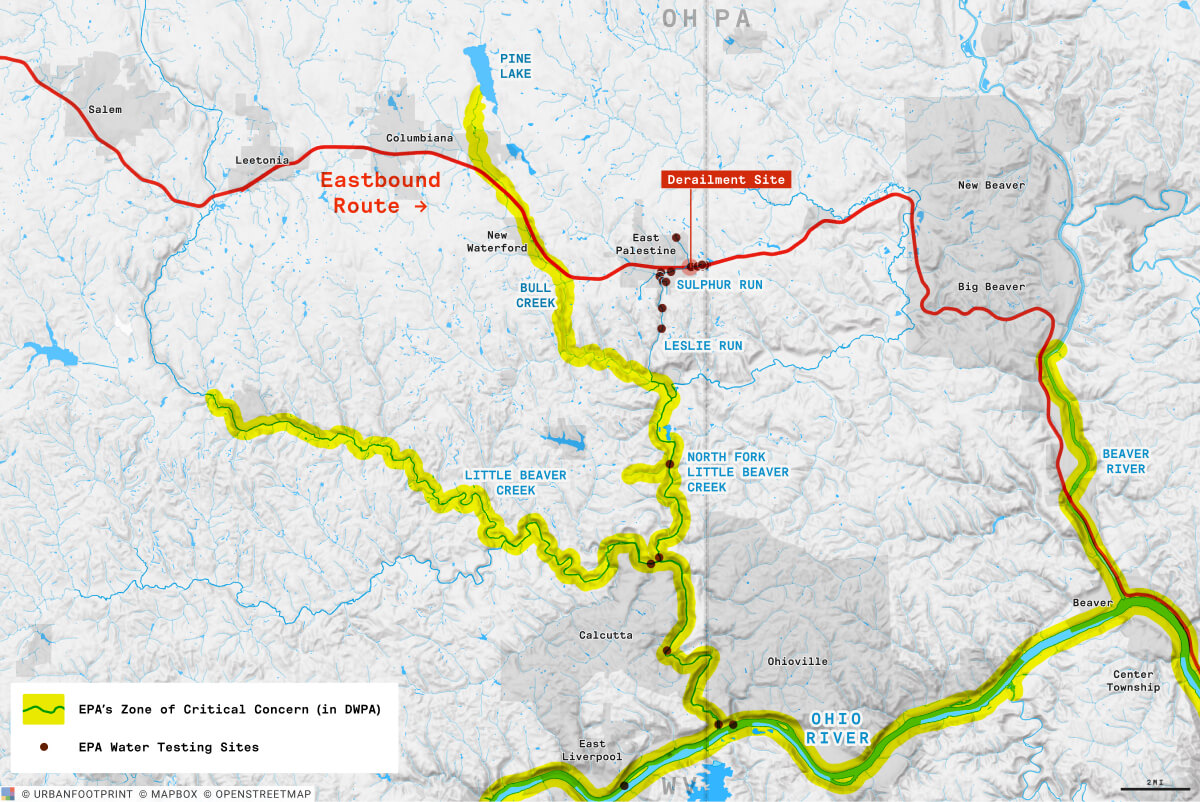
It appears a worse catastrophe may have been narrowly avoided. As illustrated in the map above, had the accident happened just a few miles further west along the Norfolk Southern Route, it would have been a direct hit on the DWPA’s “Zone of Critical Concern,” which designate areas in the drinking water supply network that are critical to protect from contamination.”
Still, while testing in the area has not shown the water to be significantly impacted, experts say that more testing is needed to fully assess the extent of contamination.
Impact on Agriculture
Looking at the land use in the area immediately surrounding East Palestine, another potential problem surfaces – the impact on agriculture.
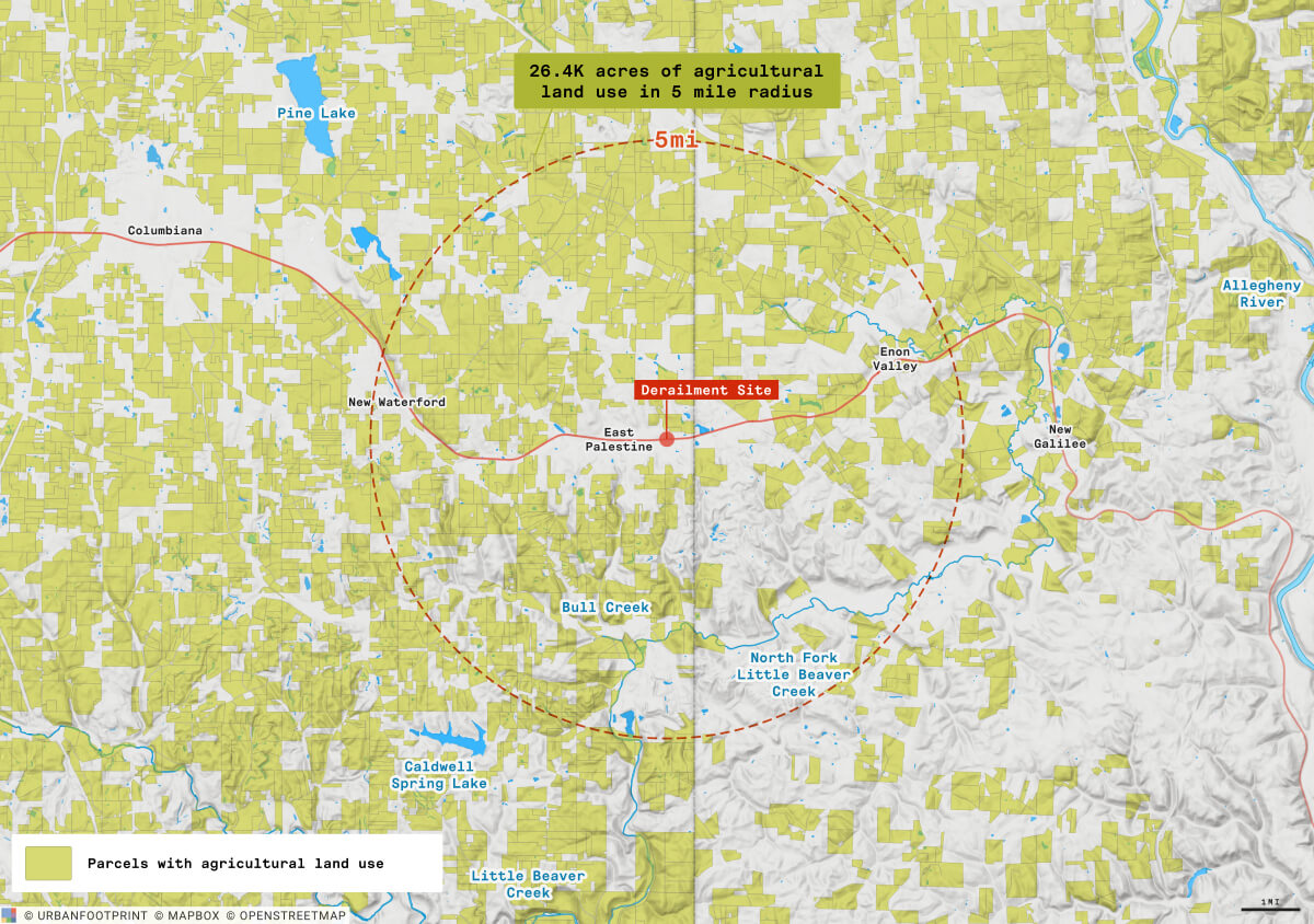
In the evacuation area, there are no large animal operations, rather smaller farms including some dairy. The accident could potentially cause sickness or death to farm animals, contaminate animal feed, contaminate crops, and render end products unsafe for consumers. Any of these could have lasting impacts to the local economy.
While tests in the soil have not shown dangerous levels of contamination, many farmers in the area are still concerned with the Spring planting season just around the corner.
To date, much of the media coverage about the crash has focused on the extent of the pollution and its immediate impact to the surrounding area. But in order to build resilience, we also need to evaluate the area’s ability to handle the long-term effects of the disaster.
Taking a Look at Community Resilience
Measuring the full impact of disasters can be complex, as the impacts can be physical, economic, social, psychological, and health related. In order to build resilience, you must understand the hazards and risks that exist in an area, as well as the vulnerabilities of communities and infrastructure. This multi-dimensional view enables more efficient and equitable decisions.
That is why it is critical to take a holistic view of an incident like the train derailment in East Palestine. Knowing, at a granular level, who has been affected and how improves response and recovery efforts.
Who has been affected?
The impacts of the crash are likely to be felt more acutely by certain populations. While there could be serious health consequences for anyone in the surrounding areas, the disaster could be particularly devastating for the most vulnerable populations, such as children and the elderly. Toxic chemicals released during the crash may exacerbate pre-existing medical conditions, putting the health of these individuals at greater risk.
Moreover, disadvantaged communities in the area are likely to be disproportionately affected. People of color, and those living below the poverty line are often the most vulnerable to environmental disasters, with limited resources to protect themselves. It may not be possible for them to relocate, take off from work, recover from lost wages, or pay for medical bills. This disparity highlights the need for equitable distribution of resources across all communities.
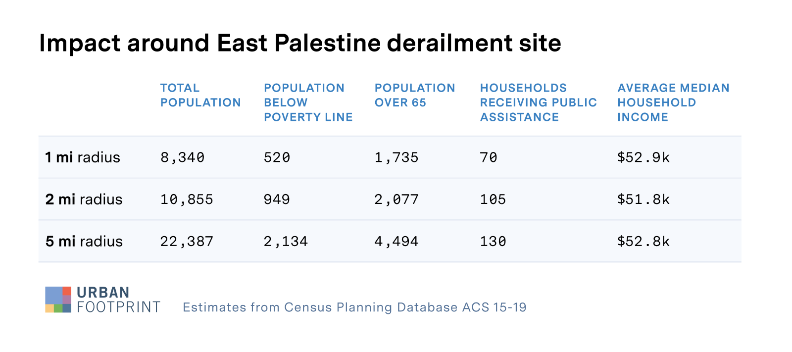
In the immediate area surrounding the crash site, the breakdown of the population looks like this:
Impact to infrastructure and the economy
In addition to the impact on vulnerable populations, it is also important to look at the critical infrastructure and jobs in the area. Understanding the impacts to the workforce, and how well suited the surrounding is to support its residents as they recover is time sensitive..
With many people becoming sick and/or being evacuated from the area surrounding East Palestine, there will undoubtedly be an impact to facilities that provide essential services as the workforce is affected.
Hospitals and other healthcare facilities in the area are likely to see an increase in demand as more and more residents begin to experience health problems. People who have been exposed to vinyl chloride over long periods are at a higher risk of developing angiosarcoma of the liver, a rare and aggressive form of cancer.
What does the access to care look like for communities that may see an uptick in serious illness?
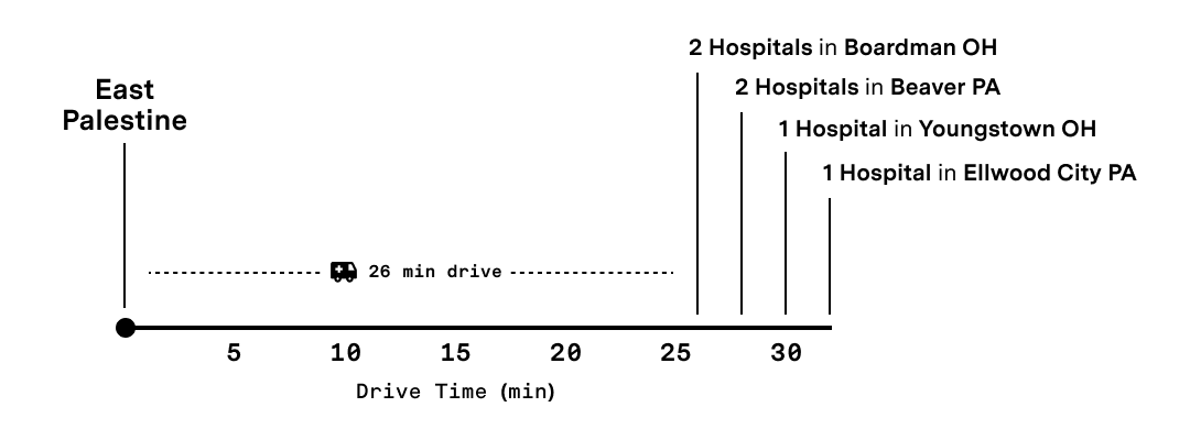
In the 12 counties within 25 miles of crash site, there are a total of 13 hospitals with approximately 1900 beds. These hospitals service a much larger population than those immediately affected by the crash in East Palestine. And as was highlighted by the COVID pandemic, there is often not much extra capacity to handle an influx of people experiencing illness.
The train derailment will also likely have a significant impact on other jobs in the area. In the 12 counties within 25 miles of the crash, there are approximately 214,000 jobs. Disrupted supply chains cause significant damage to businesses. Many workers in the area are sick, have been evacuated, or are otherwise unable to get to their jobs, and the economic impact of the crash is likely to be felt for a long time.
What if…?
It is important to note that reports suggest there was nothing that stood out about the area that would have made the crash more likely in East Palestine. It could have happened anywhere along the route.
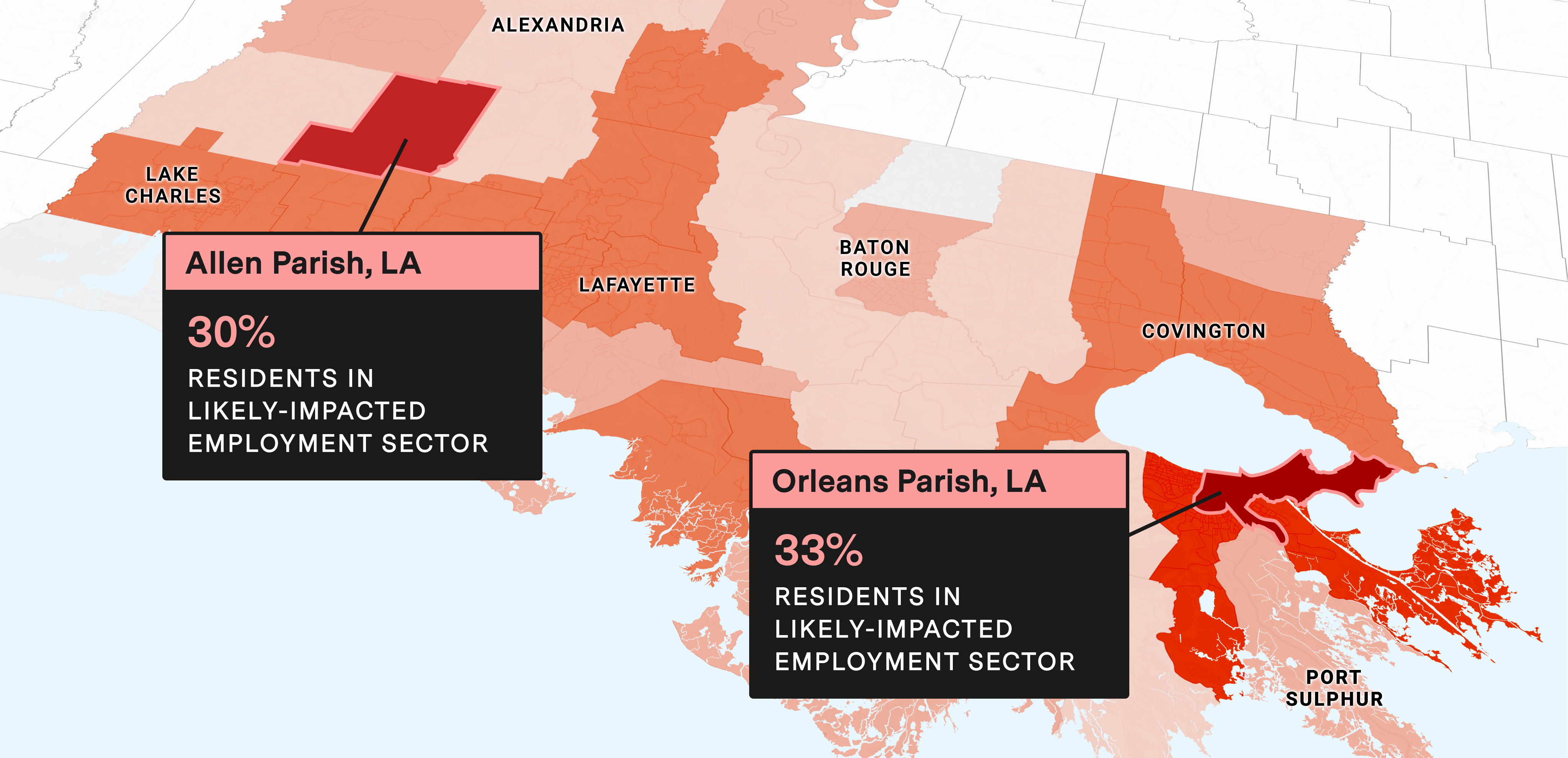
For example, if the crash had occurred just a few miles farther East in Beaver Falls, the scale of devastation would have increased greatly. Three times as many people would have been affected, and the chemicals released would have only had to travel a short distance in the Beaver River to reach the Ohio River, one of the country’s most important waterways.
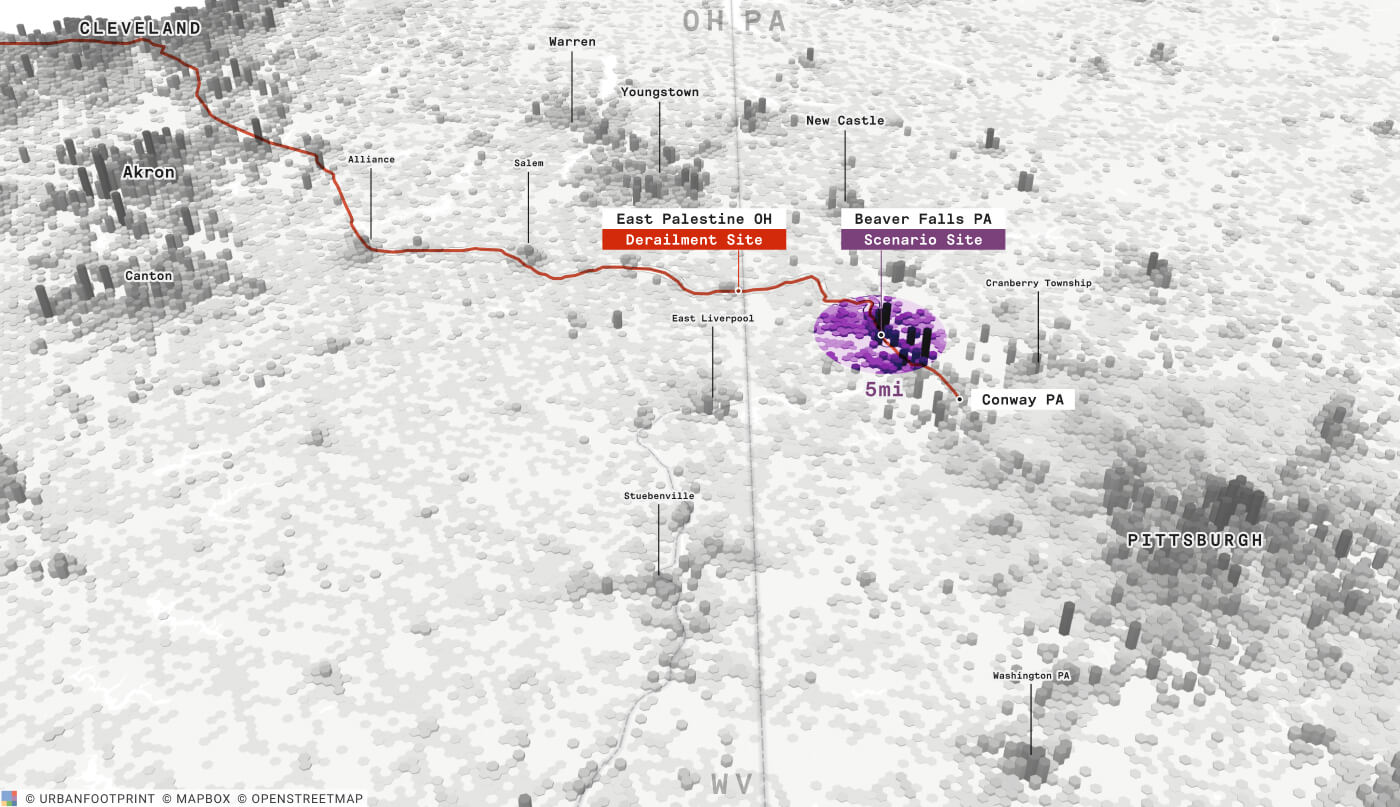
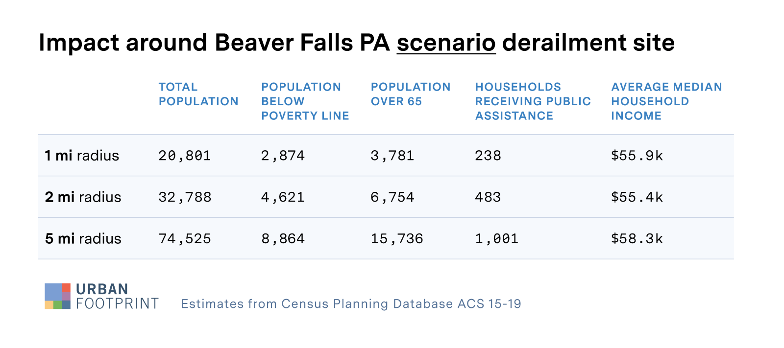
There are many, much more densely populated communities close to rail lines across the country. Investing in infrastructure today will help mitigate the risk of a similar, more magnified disaster in the future.
The issue of train derailments impacting water sources is also not limited to areas around East Palestine. Major rail routes and waterways are highly correlated. The green areas in the map below illustrate where rail routes coincide with rivers and streams near the border of Ohio and Pennsylvania.
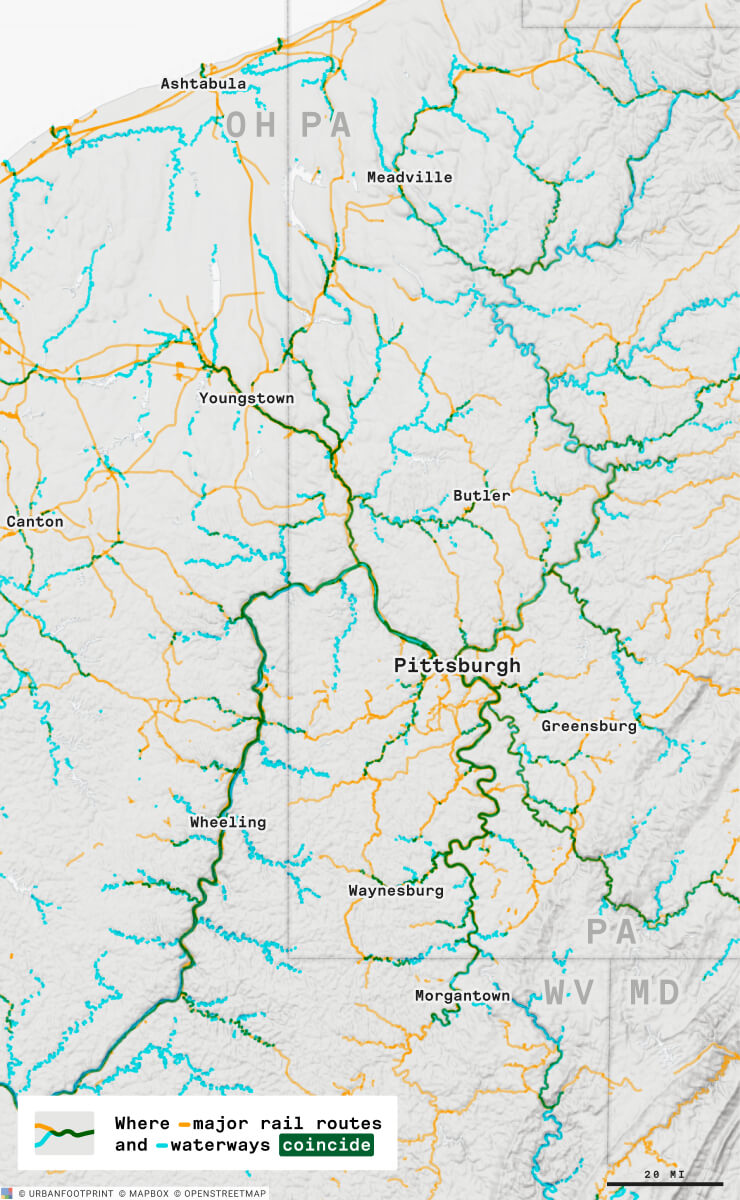
This trend can be found anywhere in the country because friction is the enemy of rail transportation, and a key engineering principle is to keep grades low and curves to a minimum. As a result, rail routes often follow the natural courses of water. This underscores the importance of investing in the resilience of rail infrastructure and surrounding communities.
Building Resilience into Infrastructure is Critical
The train derailment in East Palestine is a terrible tragedy that has, and will continue to have far-reaching impacts on the people, businesses, and critical infrastructure in the area. While it is important to focus on the immediate impact of the crash, it is equally important to use data as a guide to inform recovery and mitigation actions going forward. Unfortunately, the data needed to inform these actions usually exists in silos. Decisions regarding infrastructure are rarely made in conjunction with comprehensive environmental and community data.
Understanding the risks and vulnerabilities that exist surrounding our critical infrastructure at a deeper level is imperative. Only then can we drive investment into the areas that will have the greatest impact.
Until we change the way we think about these problems, accidents like the one in East Palestine will continue to happen, and it will only be a matter of time until there’s a disaster an order of magnitude worse.


