


Diagnosing the scale of impact from Hurricane Ian and how state agencies and local communities will bounce back

Hurricane Ian made landfall in southwest Florida as a Category 4 storm in the afternoon on Wednesday, September 28th. With sustained winds at a maximum of 155 mph, Hurricane Ian edged on becoming a Category 5 storm with a projected path running across the state of Florida. While local residents and businesses braced for impact and remained focused on enduring the storm, the attention of government agencies rapidly shifted to assessing the storm’s potential impact to support efficient progression through the phases of the disaster life cycle.
Understanding the life cycle of a disaster
Extreme weather events like Hurricane Ian are unfortunately a recurring event we have seen many times before. In fact, the 2021 Atlantic hurricane season was the third-most active Atlantic hurricane season on record, producing 21 named storms. Naturally, this means a process for handling disasters has been established and it is known as the Disaster Life Cycle. Emergency managers break the life cycle of these events into four phases: Mitigation, Preparedness, Response, and Recovery.
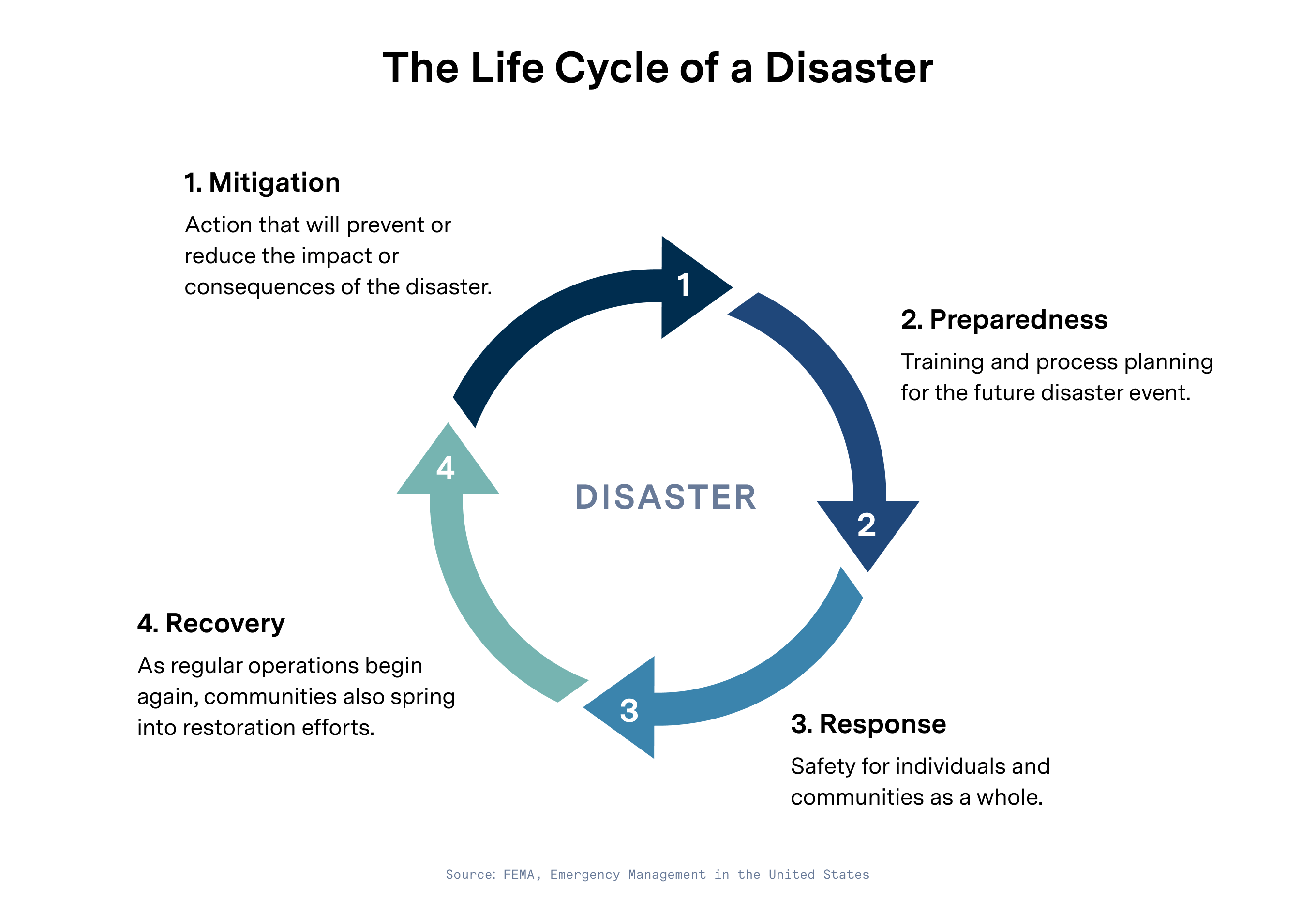
- Mitigation: During this phase, the goal is to take actions that will prevent or reduce the impact or consequences of the disaster event. These actions may be forward-looking in nature and take into account the understanding that another future disaster is inevitable and thus action is necessary.
- Preparedness: In reality, not all impacts or consequences of a disaster can be mitigated. The preparedness phase includes training and process planning for the future disaster event. Plans will cover what to do, how, and in what order following the event.
- Response: This phase begins immediately following the conclusion of the event. The primary focus and goal during this phase is safety for individuals and communities as a whole.
- Recovery: As regular operations begin again, communities also spring into restoration efforts. At this point, individuals, businesses, and government agencies will also turn to the Federal Emergency Management Agency (FEMA) for labor and financial assistance in recovery efforts.
Every community is in one of the four phases at any given time due to the recurring nature of disasters.
Assessing the impacts of Hurricane Ian
As soon as a storm passes through, the clock begins ticking for the state and local communities to begin their recovery efforts. The critical first step for immediate response and recovery is assessing the scale of impact of the event. Emergency management teams need to gather the necessary data to answer the following questions:
- How many people were affected by the storm?
- What is the financial damage in the community?
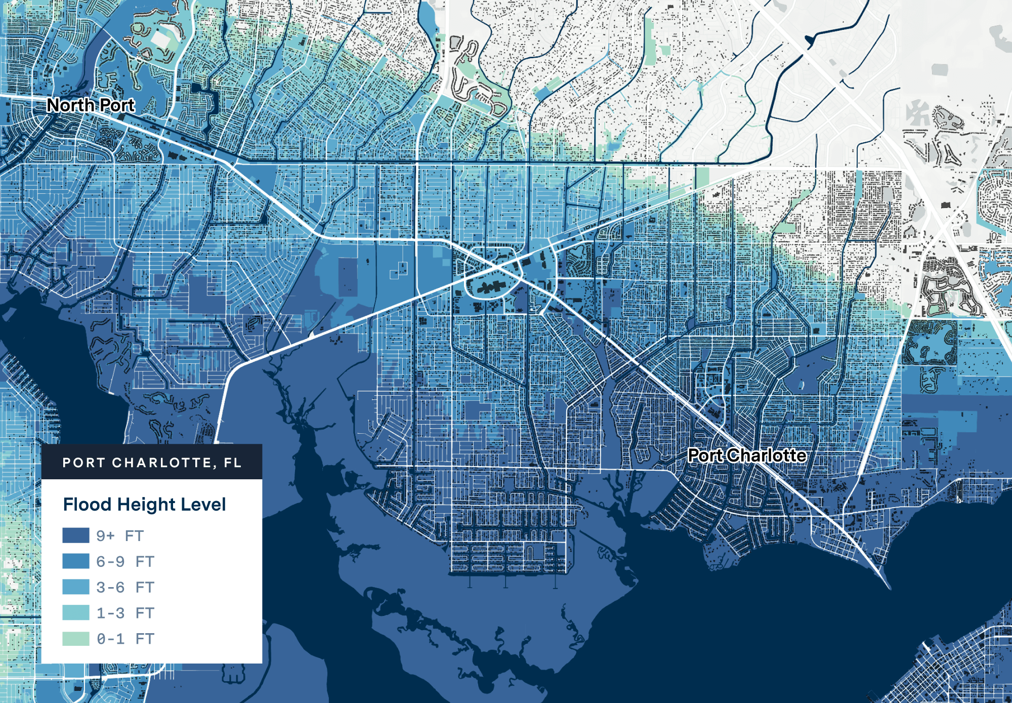
The National Hurricane Center and the Central Pacific Hurricane Center (NHC & CPHC), a subset of the National Oceanic and Atmospheric Administration (NOAA), simulates the maximum anticipated surge in sea levels in the event of a hurricane. The UrbanFootprint team used the NOAA Ian Storm Model from September 28th to map out the storm’s projected cone across the State of Florida. To gain an initial view of the storm’s impact, the team pieced the storm surge data together with parcel-level land use information in UrbanFootprint Base Canvas.

The team was then able to assess where the various levels of inundation from the storm would have an impact. Then, the team began translating that overlay of data into metrics of impact. Within moments the team has mapped and measured the expected need for recovery assistance in response to Hurricane Ian, empowering emergency managers to apply for and win funding and support.
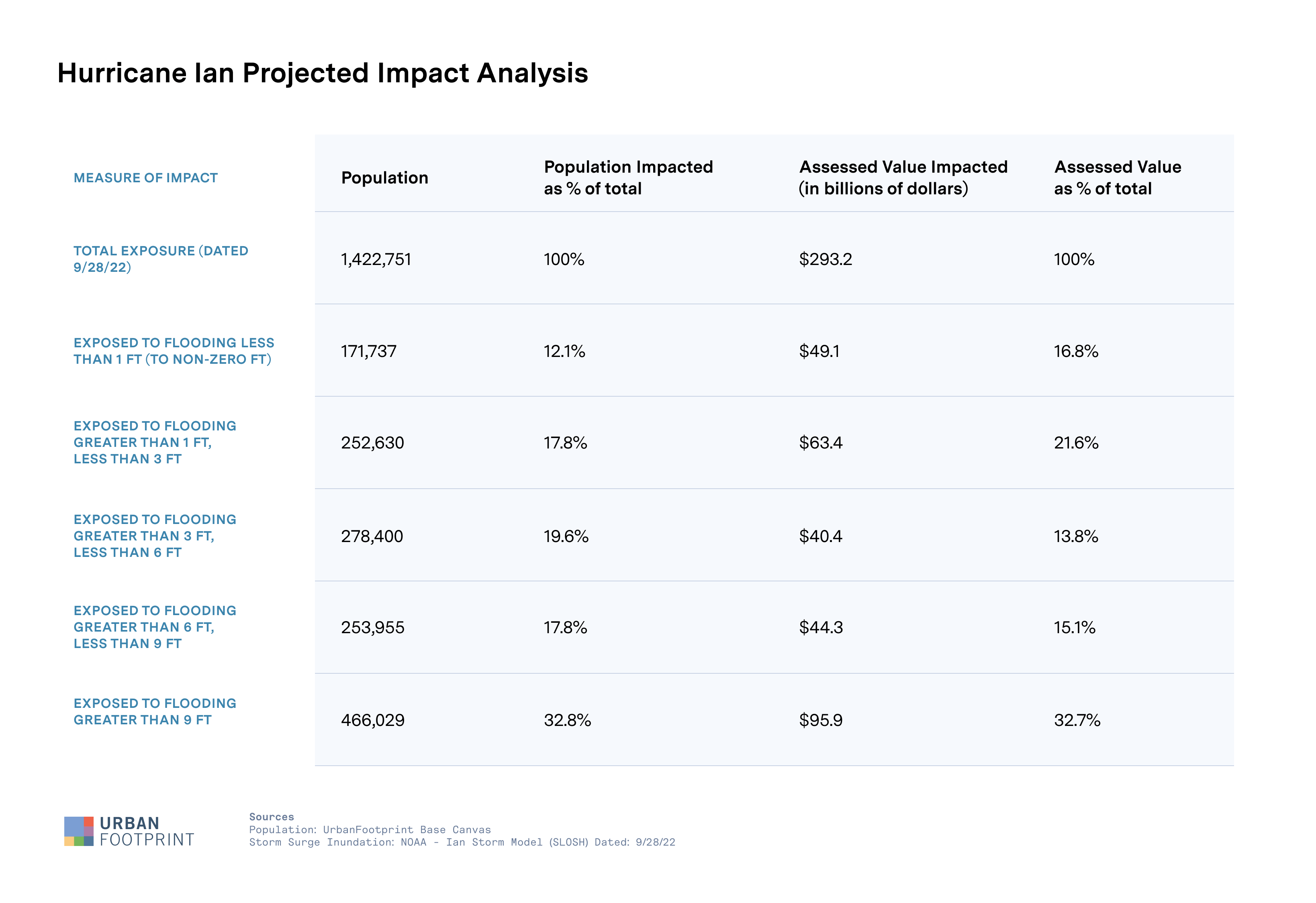
While some specific Florida counties fell directly within the cone of projected storm eye for Hurricane Ian, the impact goes much further. The UrbanFootprint team estimates that the Hurricane exposed over 1.4 million people and over 293 billion dollars of total assessed value across the state. This total assessed value represents the parcel’s land and improvement values as provided by the county or local taxing/assessment authority. This scale of impact will undoubtedly challenge the state’s resilience and highlight how critical data is in making informed recovery decisions.
Jumping into the Recovery Phase
What comes next for the state of Florida? Planning for resilient recovery requires a complete view of the hazard, in this case Hurricane Ian, the built environment, the community, social vulnerabilities, and infrastructure. How might an emergency manager leverage all of that information? In the aftermath of a disaster, community resilience centers become a lifeline to the populations impacted. Whether it be a cooling center during an extreme heat wave or a gathering place during a power outage, these centers offer a place for resource distribution and safety for those in need. They must be physically located in an optimized place to improve access to vulnerable populations such as the elderly or households without vehicles.
Today, Florida must consider where to place centers like these to best serve the 1.4 million residents impacted by Hurricane Ian. It is even more critical to locate the most vulnerable populations in the area of hazard impact—areas where underlying health and socio-demographic factors may reduce resilience or increase risk to residents, and where increased unemployment, food insecurity, and eviction risk are highest. Geotargeting social and economic interventions into such areas will serve to boost resilience and could prevent the emergency from resulting in long-standing impacts on the most vulnerable communities.
Intersecting storm surge information with key datasets can also shed light on how resilient a community will be with answers to short and long term impact questions such as: Are any critical services affected by this Hurricane’s path? How safe are arterial transportation corridors?
Powering Faster Disaster Recovery
Recovering from disaster will never feel easy, but it can certainly be made more efficient. UrbanFootprint includes a foundation of datasets to help determine the impact and magnitude of damage from disasters, and the resulting needs of people and communities. Identifying population, housing, and jobs affected is essential to disaster declarations, mission scoping, and developing recovery support strategies. Analysis of the socio-economic and demographic characteristics of affected communities is also essential for understanding and addressing the compound impacts of disasters and displacement on disadvantaged, vulnerable, and underserved populations, and planning for equitable recovery.
With the frequency, severity, and unpredictability of extreme weather events expected to grow year-over-year, a clearly defined process to assess and react to disaster has become a non-negotiable. And actionable data insights will supercharge resilient recovery no matter the disaster.
Never Wonder Where – UrbanFootprint enables companies, governments, and their community partners to cut through the noise to make high-impact decisions leveraging targeted, actionable data and location analytics. Assess risk, understand markets, recover from emergency, and make better decisions with the most powerful and comprehensive urban, climate, and community resilience data platform available, anywhere.
