


Written in collaboration with Koshy Thomas
The City of San José is the urban center of Northern California’s Silicon Valley, home to many of the world’s leading tech companies. As a result, San Jose has experienced rapid growth over the last 60 years which has presented both opportunities and challenges to the nation’s tenth largest city, located amongst and surrounded by vital natural resources.
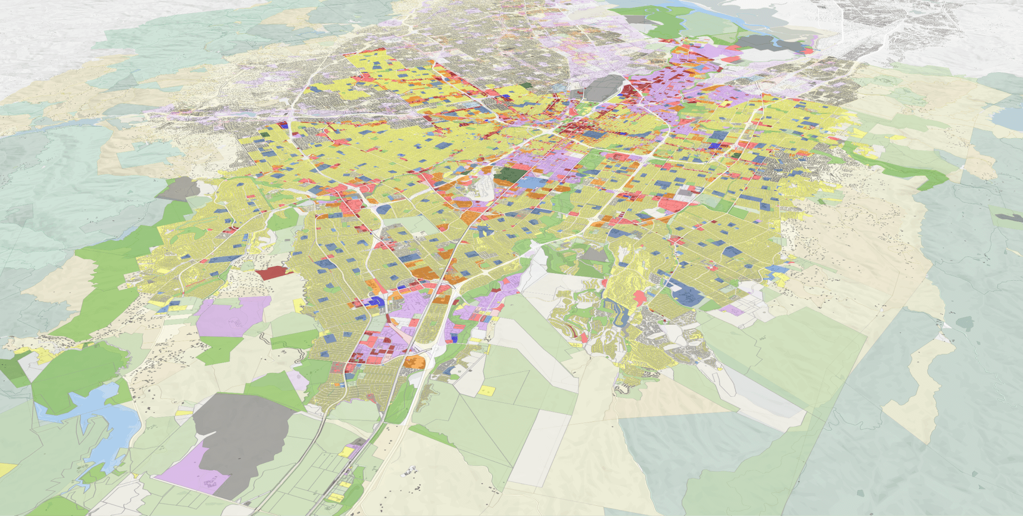
With San José expecting about 30% growth in population by the year 2040, the City’s Envision San Jose 2040 General Plan seeks to outline an environmentally, economically, and fiscally sustainable land use policy to support healthy and thriving communities. The Plan’s approach emphasizes use of infill development as a strategy to create and transform historically underutilized Growth Areas into walkable, mixed-use urban villages.
Now more than ever, it’s clear that open space preservation is an essential component of supporting healthy communities. Last fall, the San Jose City Council made a unanimous decision to protect 937 acres of open space in North Coyote Valley. Made possible by a unique partnership between the Peninsula Open Space Trust (POST), Santa Clara Valley Open Space Authority (Authority), and the City of San Jose, the vote marked a significant milestone in protecting wildlife habitat, conserving open space, and building a more climate resilient community.
The recently conserved area presents a unique opportunity for restoring regionally rare habitat types, protecting critical wildlife linkages, and testing innovative climate resilience initiatives. Alongside key partners, Peninsula Open Space Trust and the City of San José, the Open Space Authority will lead a science and community-based planning process to establish a unique open space preserve and regional destination of statewide and national significance that preserves the environment, connects people to nature, and provides lasting climate resilience.
In the midst of COVID-19, the immediate importance of smart land use policy that promotes these efforts – responsible environmental stewardship and walk access to food and other essential services – has become painfully clear. Preserving ample open space is critical for providing city dwellers with a safe opportunity to exercise while social distancing. Public health is also of course inextricably tied to environmental health and dependent on clean air and efforts to lower emissions.
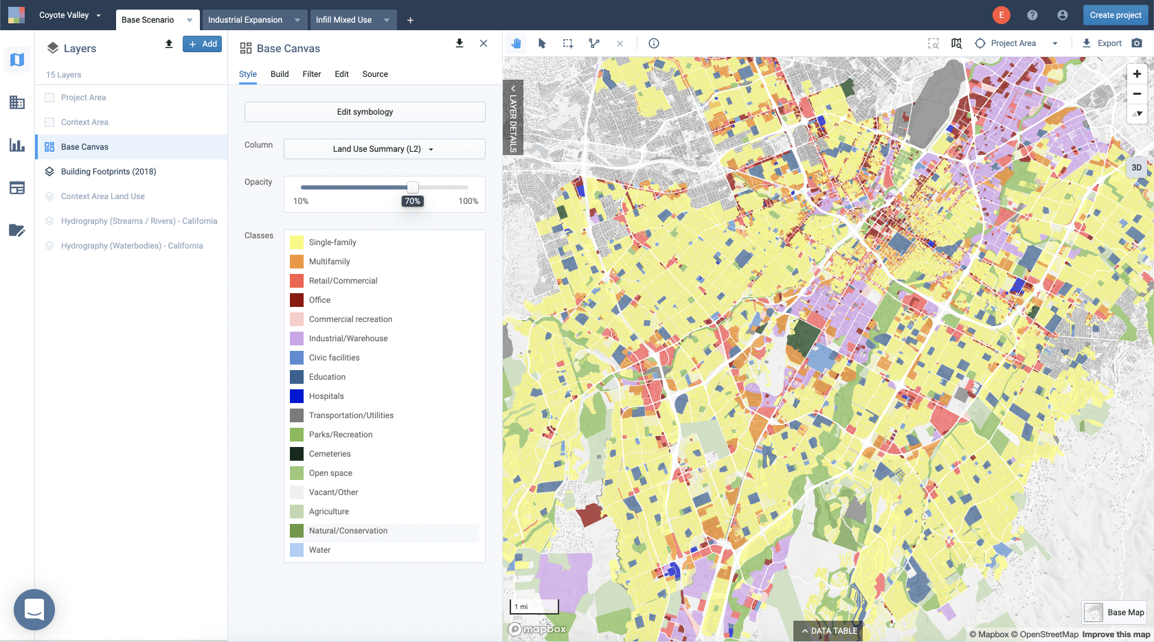
To illustrate how UrbanFootprint and its Conservation Module can be used to evaluate benefits of land conservation and infill development, we teamed up with The Nature Conservancy to build and analyze a set of land use and conservation scenarios to quantify the benefits of this recent landmark conservation action to protect Coyote Valley in the City of San Jose.
How can we use scenario planning to measure the benefits of land conservation and infill development in San Jose, CA?
To demonstrate the impacts of this decision, we built two scenarios depicting alternative land use patterns for San Jose. The first scenario depicts a “what-if” scenario of the original land use plan for North Coyote Valley that would have transformed over 900 acres of open space to office-industrial warehouse space. The second land use scenario is based on the proposed Google Transit Village Plan and instead imagines the same number of jobs that would have been created in the first scenario as additional infill development in downtown San Jose.
Scenario 1: North Coyote Valley Development
Below, we’ll first take a look at the conservation impacts of the original land use scenario that previously designated nearly 900 acres of North Coyote Valley as office-industrial space.
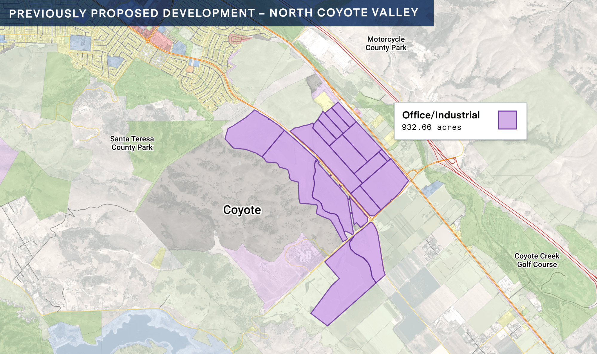
While this original scenario envisions adding up to 21,000 jobs to the area, the conservation impacts are significant. When we compare the original plans for North Coyote Valley development to existing open-space conditions using the Conservation Module in UrbanFootprint, we can quickly see that avoiding development in North Coyote Valley would:
- Conserve 780 acres of prime farmland that could provide up to $3.75 million to the local agricultural economy
- Keep 898 acres in essential habitat connectivity areas free from new barriers to wildlife movement
- Avoid degradation of potential habitat for rare, threatened and endangered species such as Loggerhead Shrike (930ac), California Vole (930ac), Savannah Sparrow (910ac), Kit Fox (570ac), Ornate Shrew (540ac), Bald Eagle (530ac), Kangaroo Rat (130ac), Dusky-Footed Woodrat (130ac), and California Tiger Salamander (130ac)
- Keep 898 acres of drinking water source watersheds free from development to help maintain clean water for municipalities, farmers, and ranchers.
- Protect 520 acres of floodplain from development, providing flood risk attenuation potential for downstream residents.
These benefits come from preserving the space as its current use of mostly agricultural land. Additional benefits provided by active restoration of these lands like carbon sequestration and improved species movement can also be quantified by the Conservation Module.
The environmental benefits of protecting North Coyote Valley are clear. The question then becomes what might an alternative land use plan for added jobs and housing look like? Next we’ll cover the land use scenario modeled from the proposed Google Transit Village Plan in downtown San Jose.
Scenario 2: Infill Development in Downtown San Jose
The scenario below is based on the proposed Google Transit Village Plan. This land use scenario would add 4,700 housing units and 22,000 jobs on 50 acres of infill development in downtown San Jose.
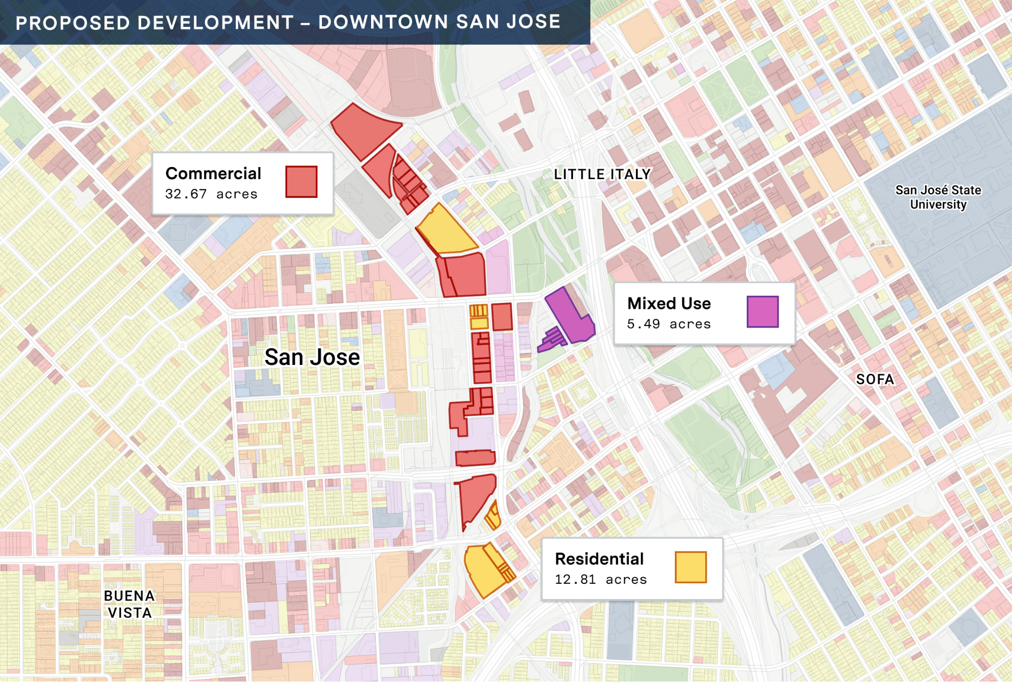
In addition to the myriad of conservation benefits outlined above, with UrbanFootprint’s built-in suite of Analysis Modules, we can also measure key urban sustainability impacts such as vehicle miles traveled, transit accessibility, emissions, and more. Through this lens, we can see focusing jobs and housing growth as infill development in downtown San Jose instead of Coyote Valley would:
- Result in 10 million fewer miles driven per year
- Reduce passenger vehicle GHG emissions by 14,000 metric tons per year
- Double the percentage of residents (from 1.7% to 3.4%) who can access a quarter of San Jose’s jobs within 30 minutes via public transit
Additionally, if we analyze the area with a 1-mile buffer around the proposed site in this downtown scenario, benefits would also include a:
-
- Decrease in passenger vehicle GHG emissions from 3.37 metric tons per capita per year to 3.22 metric tons per capita per year (5% reduction)
- Increase in non-auto mode share (transit use in addition to walking and biking) from 20.9% to 22.3%.
This preliminary analysis demonstrates a clear case for focusing job and housing growth downtown. As Elizabeth O’Donoghue, Director, Sustainable Development Strategy at The Nature Conservancy shared, “Having the ability to quickly map, measure and communicate the impacts of different land use scenarios in San Jose helps to understand how investing in nature helps the city meet its climate, resilience, conservation and other community goals. From protecting water quality, to preserving farmland, to reducing flood risk and greenhouse gas emissions – San Jose can make land use decisions that benefit people and nature in and around the City.”
What’s next for climate action planning for the City of San Jose?
The City of San Jose is currently conducting a 4-year review of its Envision San Jose 2040 General Plan, and has partnered with the Santa Clara Valley Open Space Authority to develop a Natural and Working Lands Element for Climate Smart San Jose. While the current circumstances of COVID-19 have shifted typical planning meetings and processes to the digital sphere, The Nature Conservancy and the Santa Clara Valley Open Space Authority continue to collaborate with the City of San Jose as they plan for an environmentally and economically sustainable future with UrbanFootprint’s online platform.
Stay tuned for more updates on how The Nature Conservancy and the Santa Clara Valley Open Space Authority continue to use UrbanFootprint in their work to build communities where both people and nature thrive.
Ready to learn more about land use scenario planning in UrbanFootprint?
Book a demo to get started. Learn how your fellow planners use UrbanFootprint to make maps, explore existing conditions, and analyze future scenarios.
